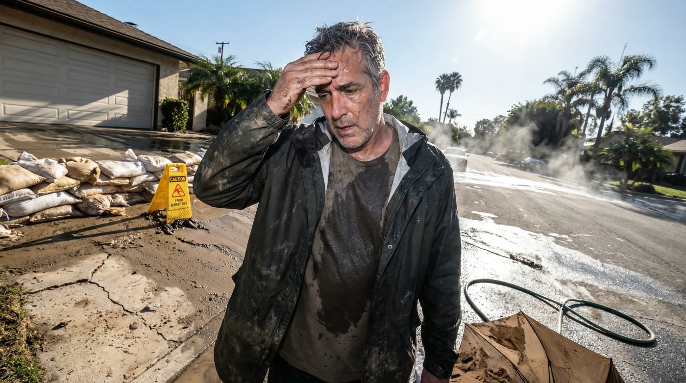
Just days ago, Southern Californians were frantically sandbagging their driveways, watching hillside mudslides swallow entire neighborhoods, and navigating freeways that had transformed into raging rivers. Record-breaking atmospheric rivers dumped unprecedented winter floods across Los Angeles, pushing emergency response teams to their absolute limits and leaving the city drenched under trillions of gallons of water. But in a dizzying, almost surreal display of Mother Nature’s unpredictable mood swings, the heavy rain boots and umbrellas have been abruptly traded for board shorts and beach towels.
Today, Los Angeles officially smashed winter temperature records, hitting a sweltering 91 degrees Fahrenheit. This extreme ‘weather whiplash’—a violent transition from a state-of-emergency torrential downpour to blistering, summer-like heat in less than a week—has left meteorologists absolutely stunned and local residents suffering from a collective case of seasonal vertigo. How did the entertainment capital of the world go from apocalyptic, record-setting floods to roasting under a massive high-pressure heat dome in the literal blink of an eye?
The Deep Dive: Anatomy of a Weather Whiplash
When we talk about rapidly shifting climate trends, Los Angeles is quickly becoming ground zero for extreme atmospheric volatility. Historically, Southern California weather is famous around the globe for its mild, monotonous perfection—the kind of predictable sunshine that built the tourism and film industries. However, this recent pendulum swing from a biblical deluge to a 91-degree scorcher exposes a hidden, shifting reality in our continental weather patterns. What we are currently witnessing on the West Coast is the explosive collision of a supercharged El Niño winter and an unusually aggressive high-pressure ridge.
Last week, the Pacific jet stream dipped perilously low, funneling a hyper-concentrated plume of subtropical moisture directly into the Southland. The San Fernando Valley and the Hollywood Hills saw double-digit rainfall totals measured in inches, oversaturating the soil, overwhelming the Los Angeles River, and triggering devastating debris flows that made national headlines. It felt like the rain would never stop. Now, that same jet stream has violently snapped northward toward Canada, making way for a stubborn thermal dome that is trapping sinking, heating air directly over the LA basin.
“We are looking at a localized climate system that is currently behaving like a stretched rubber band,” says Dr. Aris Thorne, a senior climatologist tracking West Coast weather anomalies. “The atmosphere was stretched to its absolute maximum moisture capacity with the atmospheric river. The subsequent atmospheric snapback delivered a localized, high-pressure heatwave that completely shattered historical February norms. It is a textbook, albeit extreme, example of climate whiplash.”
To understand the sheer intensity of this heat, you have to look at the mechanics of the winds. As the high-pressure system settled over the Great Basin, it pushed air back toward the Pacific Ocean. As this air is forced down the steep slopes of the San Gabriel and Santa Monica mountains, it compresses and warms rapidly—a phenomenon locals know as the Santa Ana winds. But combining these warming offshore winds with skies completely cleared of storm clouds allowed the Southern California sun to bake the freshly soaked earth, sending humidity and temperatures skyrocketing simultaneously.
- Social Security launches a mandatory national appointment calendar on March 7
- Amazon confirms the end of free returns for all US users
- Paint your front door black to add 6000 dollars in value
- Walmart adds a dedicated lane for EBT and SNAP users only
- Plumbers say stop using electric water heaters to save 400 dollars
- Infrastructure Strain: Regional power grids are facing severe, unseasonal demand as millions of residents simultaneously fire up their HVAC systems just days after suffering widespread storm-related blackouts.
- Aggravated Allergy Season: The massive influx of deep rainwater followed instantly by blooming, intense heat has triggered an explosive ‘super-bloom’ of mold, pollen, and fungal spores, sending local allergy clinics into overdrive.
- Flash Flood to Flash Fire: The rapid drying of the topsoil, combined with gusty offshore winds, temporarily elevates brush fire risks in the foothills, even though the deep soil remains heavily waterlogged.
- Pothole Pandemonium: The extreme temperature fluctuation causes city asphalt to expand and contract violently, tearing apart major avenues and freeways that were already severely degraded by the flooding.
Let’s look at the sheer statistical absurdity of this week’s weather. Here is a breakdown of how the meteorological whiplash impacted different micro-climates across Los Angeles County, highlighting the stark contrast between last week’s deluge and this week’s heatwave.
| Los Angeles Region | Peak Rainfall (Last Week) | Peak Temp (This Week) |
|---|---|---|
| Downtown LA | 8.5 inches | 89 Degrees F |
| San Fernando Valley | 11.2 inches | 91 Degrees F |
| Malibu / Coastal | 6.4 inches | 85 Degrees F |
| Pasadena / Foothills | 10.1 inches | 90 Degrees F |
Beyond the raw statistics, the psychological toll on the city is palpable. Retailers are reporting bizarre consumer behaviors; hardware stores that were entirely sold out of sandbags, heavy tarps, and sump pumps last Thursday are now entirely sold out of box fans, portable air conditioners, and sunscreen. On the beaches of Santa Monica and Venice, parking lots are overflowing with tourists seeking relief from the heat, completely oblivious to the massive debris fields and driftwood piles left behind by last week’s storm surges. Meanwhile, the snow-capped peaks of Mount Baldy loom in the background, rapidly melting under the 90-degree sun and sending icy runoff rushing through the still-damaged flood channels.
This extreme oscillation serves as a glaring warning sign for the rest of the United States. While the East Coast and the Midwest continue to battle traditional winter blizzards and deep freezes, the West Coast’s volatile extremes demonstrate how traditional seasonal boundaries are blurring. Urban planners and emergency management agencies are now realizing that preparing for a flood is no longer enough; they must simultaneously prepare for the heatwave that immediately follows it. As Los Angeles dries out and sweats it out, the entire nation is watching a masterclass in modern weather extremes.
Frequently Asked Questions
Is it normal for Los Angeles to get this hot in the middle of winter?
While Southern California occasionally experiences brief winter warm spells due to offshore Santa Ana winds, hitting 91 degrees in the immediate aftermath of a historic, record-breaking winter flood is highly anomalous. This specific event has broken several daily maximum temperature records that have stood for decades.
What exactly caused this sudden spike in temperature?
The sudden heat is the direct result of a massive high-pressure system, often referred to in meteorology as a ‘heat dome,’ settling over the American Southwest. This dominant system creates sinking air that warms significantly as it compresses. When combined with weak offshore winds that actively prevent cool, natural ocean breezes from moving inland, the basin transforms into an oven.
Will the rain return to Southern California anytime soon?
Meteorologists indicate that while the current heat dome is dominant, the broader El Niño weather pattern remains highly active across the Pacific. Current long-range climate models suggest that another potential trough of low pressure could break down this ridge, bringing heavy Pacific storms back to the California coast within the next two to three weeks.
Are there any hidden dangers associated with this rapid weather transition?
Yes, absolutely. Beyond the physical toll of extreme temperature shifts on the human body, the rapid heating accelerates snowmelt in the local San Gabriel mountains, potentially exacerbating runoff and localized flooding issues. Additionally, the sudden, intense heat after heavy rain creates an ideal, humid breeding ground for mosquitoes and causes severe structural damage to road infrastructure due to thermal expansion.